Last year, we reported on some mysterious booms in a small Wisconsin town that turned out to be small earthquakes. While it was an unusual story, it’s actually not that uncommon of an occurrence. Early in the summer of 2001, folks in Spokane, Washington started reporting similar booms. The sounds continued, off and on, for about five months. The mystery didn’t last long, as the earthquakes responsible were picked up by seismometers in the area. (A particularly loud one that took place exactly one month after the September 11, 2001 terrorist attacks in New York did rattle some nerves, however.)
In total, 105 earthquakes were detected, with a couple as large as magnitude 4.0. For most of them, there wasn’t good enough seismometer coverage to really pinpoint locations, but some temporary units deployed around the city in July located a number of events pretty precisely: the earthquakes were centered directly beneath the city itself.
While a dangerously large earthquake is pretty unlikely in Wisconsin, the possibility can’t be ignored in Washington. The 2011 earthquake in Christchurch, New Zealand was only a magnitude 6.3, but the damage was extensive because the epicenter was so close to the city. In L’Aquila, Italy, a swarm of small earthquakes in 2009 was followed by a deadly magnitude 6.3. (The poor public communication of risk during that swarm netted six seismologists manslaughter convictions.)
For obvious reasons, it’s important to learn more about what’s going on beneath Spokane. A group of researchers from the US Geological Survey and the Pacific Northwest Seismic Network have turned to satellites to start piecing the story together.
InSAR (or interferometric synthetic aperture radar) data from satellites allows scientists to detect exceedingly small changes in land surface elevation, such as occurs when crustal blocks shift during an earthquake. Data collected by European Space Agency and Canadian Space Agency satellites show surface movement along a fault running northeast from the center of the city. Despite the fact that the data were gathered from space, they were able to show a maximum change of about 15 millimeters.
The researchers used computer models to work out the earthquake characteristics that would be consistent with all the available data. They came up with shallow earthquakes centered 0.3 to 2 kilometers below the surface involving a thrust motion on the fault—meaning that one block is being pushed up and over the other—totaling about 45 millimeters.
Evidence of the fault in the landscape beyond city limits is inconclusive. The floodwaters from the draining of glacial Lake Missoula scoured that area, potentially erasing or obscuring any fault scars that had been present. There is a known fault that skirts the other side of the city, however, and it’s possible that this fault branches off it.
In order to assess the risk of larger earthquakes near Spokane, seismologists will have to learn more about the structure of the fault and what makes it tick. If you don’t understand the stress building along the fault, you can’t know how big the resulting earthquakes can be.
Your subwoofer does not impress me, mortal
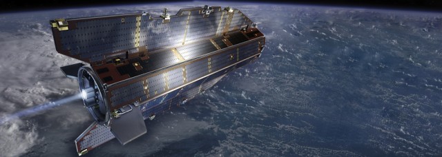
The noise associated with these small quakes may have shaken up local residents, but the phenomenon isn't limited to small earthquakes. The 2011 magnitude 9.0 Tohoku-Oki earthquake in Japan also made some noise—enough that it was detectable from 270 kilometers up.
The European Space Agency’s GOCE satellite was not designed to be an earthquake eavesdropper. The satellite is basically a giant accelerometer capable of incredibly precise measurements of gravity, and it's normally used to study Earth processes like ocean circulation and melting ice sheets. But a group of researchers from France and the Netherlands decided to examine the satellite’s data for any signals related to the massive earthquake in Japan. They weren’t looking for changes of the Earth’s surface—they were looking for the direct effect of the earthquake’s infrasound boom reaching the satellite.
And that’s just what they found. The satellite’s accelerometer picked up the subtle effect of the acoustic wave traveling through it. What’s more, since the satellite’s orbit is still technically in the Earth’s atmosphere, it could detect the fluctuations in air density caused by the passing sound waves. The satellite's activity depend on maintaining it in an incredibly precise orbit by using jets to compensate for drag. The momentary increases in atmospheric density caused by the earthquake's sound waves increased the drag on the satellite, triggering the jets.
Since this had never been done before, the researchers claim the mantle of “first seismometer in orbit around the Earth” for the GOCE satellite. Apart from helping researchers interpret GOCE’s data, this “proof of concept” provides a new way to study interesting atmospheric phenomena related to earthquakes, like the disturbances in the ionosphere that can interfere with GPS systems.
Journal of Geophysical Research – Solid Earth, 2013. DOI: 10.1002/jgrb.50118, Geophysical Research Letters, 2013. DOI: 10.1002/grl.50205 (About DOIs).
reader comments
31