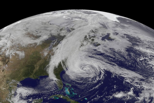
Look, it’s not easy to predict the weather. And while it’s frustrating to have weekend plans spoiled by unexpected showers, the stakes are much higher for potentially catastrophic storms like hurricanes. The warning provided ahead of “Superstorm” Sandy’s arrival on the East Coast saved lives, without question, and that’s a success for weather science. But the story carries a reminder that there’s room for improvement in the US, where many argue forecasting tools have been neglected amid continual budget crunches.
Seven days before Sandy made landfall in New Jersey, the atmospheric crystal ball was partly cloudy. The US National Weather Service forecast model showed a chance that Sandy might come ashore, but indicated that it was more likely the storm would spin off into the Atlantic. The European Centre for Medium-Range Weather Forecasts (ECMWF) model, however, definitely pointed the storm ashore. It would be about three days before the US model totally converged on the Europeans' forecast.
The fact that the National Weather Service was able to issue detailed warnings well ahead of Sandy is both a testament to what these amazing models are able to do, and the hard work of the professionals behind the scenes.
Still, some in the US couldn’t help but wonder why the European model beat its American counterpart to the punch in predicting Sandy’s landward turn. Did it get lucky or is it a superior model? While it doesn’t always beat the competition (it got 2012’s Tropical Storm Debby wrong, for example), most scientists agree that the European model holds a clear advantage. Sandy just brought that fact before the public eye.
Weather wizard needs food, badly
Like any suburbanite who finds themselves coveting a neighbor’s flashy new gizmo, we first need to understand what, exactly, that gizmo is. Forecasting models are computer simulations of the global atmosphere. They’re similar to the models used by climate scientists, but with fewer components—leaving out slowly-changing factors like ocean circulation, vegetation, and atmospheric gas concentrations. Forecast models can also be run at a higher resolution that can better simulate local-scale weather. Data from around the globe is fed into the model, which then simulates the consequences of atmospheric physics into the near future.
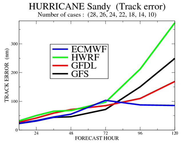
Forecast models require some serious computational horsepower, which can only be supplied by supercomputers. The ECMWF, for example, utilizes an IBM system capable of over 600 teraflops that ranks among the most powerful in the world, and it's used specifically for medium-range models That, fundamentally, is the reason their model frequently outperforms the American one. The US National Weather Service’s modeling center runs a diversity of short-, medium-, and long-term models, all on a much smaller supercomputer. The National Weather Service has to do more with less.
This computational bottleneck limits the US model in two key ways. First, it runs at a coarser spatial resolution (about 25 kilometers, as opposed to 15 in the ECMWF model). Anything in the atmosphere that takes place at a smaller scale has to be approximated. In general, finer resolution models can directly simulate more processes, especially once you reach the scale of an individual storm cell.
Second, the way in which measurements are fed into the models differs. The US model takes “snapshots” of data, builds a global picture (the initial conditions), and then begins the forecast simulation. The ECMWF model, on the other hand, takes continuous observations spanning half a day, runs the model with that real data, and then sets it loose on the future. While computationally expensive, this can result in more realistic initial conditions, and is part of the reason why the ECMWF model is usually reliable a couple days further into the future then the US model.
Tomorrow's forecast with yesterday's budget
The US model has lagged behind in these areas for a number of years, but the money needed to push ahead has never shaken loose. The National Centers for Environmental Prediction did get a new building this year, and an upgrade to the supercomputer is scheduled for August 2013. Unfortunately, that upgrade won’t be nearly enough to begin catching up to the ECMWF. Cliff Mass, a professor of Atmospheric Sciences at the University of Washington, told Ars the new system would be about 50 percent more powerful than the existing one—a far cry from the performance leap he has advocated.
Other than insecurities about failing to be #1, is this a problem for the US? When the National Weather Service issued its warnings ahead of Sandy, the forecasters weren’t limited to American information. They looked at the results from the ECMWF model, as well as the Canadian and UK models. In this way, the models benefit everyone, regardless of where they come from.
But that doesn’t mean the status of the American model is irrelevant. As Mass explained to Ars, the local and regional models used for detailed, short-term forecasting utilize the simulations from the longer-range National Weather Service model. They also share its system for building initial conditions from observed data. So even if the US can lean on the ECMWF model’s forecast to help figure out what’s likely to occur six to eight days down the line, it can't do so for the local forecasts. And these are the ones Americans depend on daily.
The Future of Forecasts
Cliff Mass has argued on his blog that investments in weather forecasting capabilities would pay off handsomely, and that huge advances are waiting on the necessary computational horsepower. One such advance is the ability to run many simulations of a model and generate probability distributions for forecasts. Weather is, to an important degree, a chaotic system. Run a model twice with slightly different initial conditions, and the outcomes can be quite a bit different.
For example, when the US model was run multiple times to project Sandy’s path, some simulations showed the storm making landfall but others sent it out to sea. With a large number of simulations, a calculated probability of landfall would have better characterized the model’s forecast than eyeballing a small sample of potential outcomes. The same is true for all forecast modeling, but this obviously creates a lot more work for the supercomputers behind those models. As a result, this technique is currently not applied at resolutions as fine as the ECMWF probabilistic simulations. And in general, current models are simply too coarse to capture some important small-scale details. Finer resolution would mean better forecasts.
Of course, most agencies have a long list of great things they could do with more funding, but money is limited and budget politics aren’t going anywhere. There are always competing needs, even within US weather programs. Many of the weather satellites that provide critical data for the forecast models are American. Forecast models around the world depend heavily on that data, but a number of the satellites are aging and funding problems are threatening their replacements.
A National Research Council report released in April stated that the “number of NASA and NOAA Earth observing instruments in space by 2020 could be as little as 25 percent of the current number.” The result? “Consequences are likely to include slowing or even reversal of the steady gains in weather forecast accuracy over many years and degradation of the ability to assess and respond to natural hazards and to measure and understand changes in Earth’s climate and life support systems.”
And the forecasters' experience backs this up. After Sandy, the ECMWF ran a simple experiment. They ran their model again with the data available five days before Sandy hit New Jersey, but left out data from NASA’s polar-orbiting satellites. (Delays to the replacements for those satellites mean there’s a real possibility we could lose their capabilities in the interim.) Without that data, the ECMWF model failed to predict Sandy’s landfall.
Maintaining current forecasting capabilities will cost money, and building on that success will cost the US even more. Of course, not spending it also has a cost—the cost of unreliable forecasts (measured in dollars and, perhaps, lives) is one that we all would rather avoid.
reader comments
81