Britain's Indian summer has been turned into little more than a wistful memory after almost the entire average rainfall for September fell within 24 hours.
Few parts of the country have been spared as a front with four deep and soaking troughs has moved slowly eastwards from the Atlantic, followed belatedly by watery sunshine but then a further series of downpours.
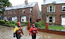
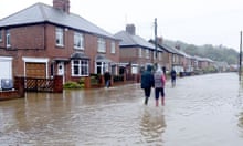
Several people died in accidents related to the weather, which mixed the rain in places with fierce gusts of wind reaching 50mph. Emergency services rescued scores of people from flooded homes or cars stuck on stretches of road which turned within minutes into impassable lakes.
The Royal Botanic Gardens at Kew in south-west London closed as a precaution after a branch fell on Sunday and killed a 30-year-woman on a visit from New Zealand. A driver also died when his car left the road between March and Wisbech on Monday morning.
Other fatalities from the wild, wet weather included a mother and toddler son from eastern Europe whose car hit a tree near Downham Market in Norfolk and a driver whose car left the road between March and Wisbech in heavy morning rain.
Disruption to services included the launching of contingency plans at the NHS blood transfusion service in Filton, Bristol, because of the scale of the local deluge, and a ban on cranes being used at the UK's busiest container port at Felixstowe, Suffolk. A spokesman said: "For the safety of all port users we are currently restricting access to operational areas. Vehicles are being marshalled on site and will be processed through to operational areas as soon as it is safe to do so."
Truck deliveries have been delayed and haulage firms warned of the disruption, but the police's Operation Stack, which organises orderly queues away from the ferries, has not yet been invoked.
The south-west's initial battering, which saw villages such as Chew Magna near Bristol almost cut off, abated but the Environment Agency had 23 flood warnings and 135 flood alerts in place, with the most serious in the West Midlands and south-west. Residents of towns habitually hit by flooding such as Tewkesbury, Gloucestershire, which has spent some £600,000 on extra defences since being swamped in 2007, have been making preparations following Sunday night and Monday morning's deluge.
Train passengers were trapped for more than two hours on trains near Bristol after a tunnel was flooded and services between Great Malvern in Worcestershire and Hereford were cancelled when part of an embankment subsided. London-bound trains from the south-west were seriously delayed.
The Met Office warned of further downpours with conditions remaining "very unsettled" everywhere but with the most persistent rain and strongest winds in the north. The forecast then shifts the heaviest weather back to southern and western England on Wednesday before drier spells later in the week.
The rain is particular relentless because the low pressure system has pulled in cooler polar air from the north, mixing it with warmer conditions and advancing at a meandering rate because the Atlantic jet stream is currently less vigorous than usual and in no hurry to blow things away. The Met Office said: "After a mainly settled start to the weekend, conditions will soon turn more unsettled again as rain spreads south-eastwards across the UK. Changeable weather is then expected through next week with showers or longer periods of rain affecting most regions. However, there should also be some drier and brighter interludes."
In the longer term the maximum 30-day forecast suggests "typical autumn weather" for much of October, with pleasant dry periods alternating with spells of rain. Temperatures should remain around average for the time of the year, too, until the end of the month when Scotland may get a foretaste of snow ahead, with the autumn's first "wintry showers".


