Our planet's warming climate has been felt most strongly in the Arctic, and the ice that covers much of the sea has been responding accordingly. Although large areas of the Arctic Ocean freeze over every winter and spring (without sunlight, things are guaranteed to get very cold), the amount of ice cover seen during the melt season has been edging down since we started monitoring by satellite. Now, a combination of the general climate trends and an unusual weather event have pushed the Arctic ice cover to record lows and, with several weeks left in the melt season, the final low could be a dramatic one.
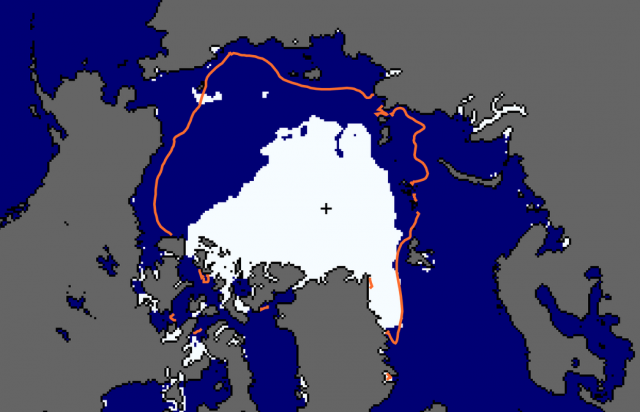
The annual rhythm of the Arctic Sea's changes looks a bit like a heartbeat. Ice starts to expand and thicken in the autumn, and reaches its peak in the early spring, a few months after the coldest part of winter. The ice then contracts, with the area covered shrinking throughout the spring and summer, and bottoming out in the first weeks of September.
Climate change hasn't stopped that cycle, but it has altered it in dramatic ways. Ice still expands rapidly in the autumn and winter—in fact, over the last few springs, the area covered with ice has often approached the average seen in the last few decades of the 20th century. (That includes this year, where May saw ice coverage that nearly reached the 1979-2000 average.)
However, the losses in recent summers, including the dramatic decline in ice seen in 2007, has changed the character of the heartbeat. Very little of this newly formed ice, which is relatively thin, can survive the warm temperatures of the summer. As a result, every year since 2007 has seen the loss of most of the thin ice formed during the winter, leading to a series of summer melts that were well below the baseline average of the satellite record.
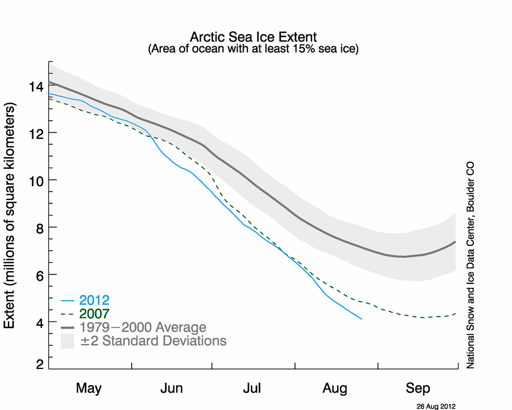
This year started off following the same script. After approaching the baseline average in the spring, the sea ice extent (measured as the area of ocean with at least 15 percent ice coverage) followed a trajectory similar to those seen in most of the last five years before spending most of July just below the levels seen in 2007, the year that had set the previous record low.
Then, in early August, weather intervened, in the form of an unusual storm that entered the Arctic ocean and parked at the pole for several days. At the time, NASA expected it meant bad things for the sea ice. “It seems that this storm has detached a large chunk of ice from the main sea ice pack. This could lead to a more serious decay of the summertime ice cover than would have been the case otherwise, even perhaps leading to a new Arctic sea ice minimum,” said Claire Parkinson, a climate scientist with NASA Goddard. “Decades ago, a storm of the same magnitude would have been less likely to have as large an impact on the sea ice, because at that time the ice cover was thicker and more expansive.”
Parkinson's predictions have now been borne out. The sea ice saw a sudden and precipitous decline that started right about the start of the storm. Even after the storm dispersed, however, the ice has continued to melt at a pace similar to that seen in the early summer, and has shown no sign of the bottoming out that often begins to be apparent at this time of e year.
The RealClimate blog, using data obtained by the National Snow and Ice Data Center, has calculated that the daily sea ice extent readings are now the lowest on record. The NSIDC itself uses a five-day running average, and so its numbers will tend to trail the trends seen in the daily readings. Nevertheless, yesterday's data shows the 2012 melt as being at or below the previous record set in 2007. (The AP is now reporting that they've also called the record low, although their website does not yet reflect this.)
The obvious question on everyone's minds is where ice coverage will bottom out. The average from the first few decades of the satellite era is in the neighborhood of 7 million square kilometers, but this year is almost certain to see a bottom somewhere below 4 million. That's still a long way from an ice-free Arctic, but it's clear that we can't dismiss that scenario as being part of some distant, purely hypothetical future. A practically ice-free Arctic—one where shipping lanes consistently stay open for weeks—is likely to come even sooner.
The less obvious question, and one we won't answer anytime soon, is whether this year's record low will trigger the sort of regime change caused by the dramatic 2007 melt. Although new record lows didn't immediately follow on 2007, none of the years that followed it ever came close to the baseline average established last century. 2007 ensured that most of the ice would be too thin to survive, making certain that every other year would be similar to it even if the temperature and weather remained roughly stable. There's a very real chance that 2012's record, even though it was driven in part by an unusual weather event, will also alter the Arctic heartbeat.
reader comments
215