
Understanding dunes is important, since he who controls the Spice controls the Universe That’s the last Dune joke, I promise.
Understanding the mechanisms behind desert sand dune formation and evolution actually is useful, since migrating dune fields threaten agricultural areas and human habitats. At the edges of dune fields, habitats can transition from lifeless deserts to areas covered in vegetation over fairly short distances. Various factors, such as the supply and transport rates of sand and groundwater, along with vegetation density, have all been proposed as key influences on this transition point, but nobody has come up with a model describing the evolution of dune fields.
Until now, that is. A team led by Douglas Jerolmack, joined by others at the Universities of Pennsylvania, Alabama, and Temple University, published a paper in a recent issue of Nature Geoscience that focused on the gypsum dunes of White Sands National Monument, New Mexico. The team came up with a model describing both the transport of the sand that forms the dunes and the changes in vegetation, relating to the levels of groundwater underneath the sand.
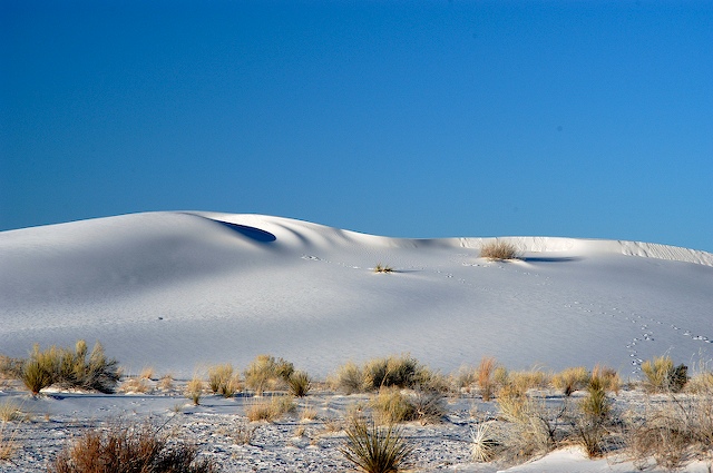
During the last ice age, the area encompassing White Sands was covered with a lake, now called Lake Otero. Around 12,000 years ago, when the climate began to change, the lake dried up and formed what’s called the Alkali Flat, which is covered in gypsum crystals. Wind eroded this surface over the past several thousand years to form gypsum dunes downwind. You might expect a slow transition between the two, but at the edge of Alkali Flat, the dune field suddenly materializes, with five meter high dunes appearing within a few hundred meters.
This transition between smooth, flat land to rough dune fields triggers the development of an internal boundary layer in the overlying air. The "internal" part comes from the fact that it lies within the larger atmospheric boundary layer.
Boundary layers are regions where the flow velocity of a medium transitions from zero at a solid surface to the free velocity away from the surface. The boundary layer starts where the dune field begins, and gets thicker as it extends across the dune field. This effect is a result of the fluid viscosity and causes a dragging shear force on the surface. (This skin friction is also a major source of drag on aircraft wings, along with pressure drag, caused by the shape of the wing.)
The formation of the boundary layer at the edge of the dune field leads to a sharp increase in shear stress, driving the movement of sand downwind. As the thickness of the boundary layer increases, the shear stress drops and less sand is transported.
Starting with a well-known equation for boundary layer growth, they added relationships for boundary layer thickness/shear stress and shear stress/sand flux, finally arriving at an analytical equation for sand flux as a function of distance downwind. Comparing this expression to data from lidar topographic maps, they found an excellent agreement, especially considering no parameters had to be changed to fit the data.
Next, they used their model to predict the transition from barren, arc-shaped barchan dunes to parabolic dunes covered in vegetation. This occurs when the transport of sand drops below a certain level, which allows plants to grow. Since the presence of plants would affect the balance of water underground, the researchers expected to find a change in groundwater depth at this transition point. Using ground-penetrating radar and wells to measure the groundwater depth, they confirmed that this change does occur. The water level dropped from an average depth of 0.5 meters to about one meter at the barchan-parabolic transition, around 8 kilometers into the dune field.
Based on their successful model, the authors propose that erosion of the Alkali Flat created the dune field, while the aerodynamics of the internal boundary layer controls sand transport and accumulation within it. This mechanism also controls the levels of groundwater by determining where vegetation can form. The dune field itself moves around 10 meters per year, driven by the wind, but the relative locations of the barchan-parabolic and accompanying groundwater depth transition remain fixed.
Understanding this formation mechanism is important not only for the inherent science but also to help predict future growth of desert areas. The model can help us understand how changes in the groundwater levels—either driven by climate change or human use—can cause the surface above to dry out, killing vegetation and allowing further erosion and desertification.
Nature Geoscience, 2012. DOI: 10.1038/ngeo1381 (About DOIs)
Listing image by Photograph by nps.gov
reader comments
17