:format(webp)/cdn.vox-cdn.com/uploads/chorus_asset/file/14291421/383_1000.1419979433.jpg)
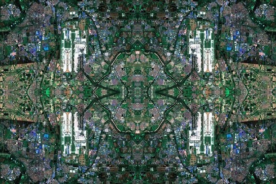
David Thomas Smith's first solo show of photographic art is called Anthropocene, and makes use of Google Maps image data in a pretty novel way — the satellite photos serve as the fabric for intricate patterns inspired by Persian rugs. Each piece uses several thousand individual images from Google Maps, which are then stitched together using Photoshop. Anthropocene is currently on show at the Copper House Gallery in Dublin; while the images look impressive enough on screen, the gallery says they have "a level of detail one can only really experience in person."
:format(webp)/cdn.vox-cdn.com/uploads/chorus_asset/file/19336098/cwelch_191031_3763_0002.jpg)
:format(webp)/cdn.vox-cdn.com/uploads/chorus_asset/file/24939904/DSCF3082_Enhanced_NR.jpg)
:format(webp)/cdn.vox-cdn.com/uploads/chorus_asset/file/24859242/236751_Instant_Camera_Buying_Guide.jpg)
:format(webp)/cdn.vox-cdn.com/uploads/chorus_asset/file/23086565/jtuohy_211209_4924_0015.jpg)